
60,000 km of roads without wheels, 200-ton blocks set without mortar, bridges suspended over canyons: we answer the big questions about Inca engineering, discovered on the Salkantay trek.
Inca engineering: the questions everyone asks?
60,000 kilometers of roads without a metal wheel. 180-ton blocks assembled without mortar. Bridges hanging over canyons several hundred meters deep. Our guide on the Salkantay asked us the question that says it all: if we can’t even understand how it was built, can we really say who built it?
What science took centuries to understand
For centuries, Spanish chronicles described Andean peoples as ignorant of astronomy, sound agriculture, geometry, and engineering. This view was folded into official history books, including the ones Peruvians themselves studied in school until the 1960s.
What archaeological discoveries from the 2000s to today have gradually revealed is quite the opposite.
The Incas, and the civilizations that came before them, mastered techniques we are only just beginning to understand thanks to modern technology. Carbon-14 dating, LiDAR (laser technology used to map structures beneath vegetation), and spectrographic analyses of rocks: these tools have revealed more about Andean engineering in two decades than four centuries of traditional research.

The paradox our guide raised on the Salkantay still stands: if we still don't have the technical means to understand how these structures were built, can we really say for sure who built them? It's not a minor question. It calls into question a large part of the certainties on which the official history of the Incas has been built.
This isn't an invitation to mysticism or alien theories. It's simply the observation that Andean history is still being written, and that what we know today will almost certainly be incomplete or partly wrong in twenty years.
60,000 km of roads: how and why?
The Inca road network is one of the most spectacular achievements in human history. 60,000 kilometers of passable roads, crossing jungles, deserts, high plateaus, and passes above 5,000 meters.
For comparison: Roman roads, long considered the pinnacle of ancient road engineering, reached about 30,000 kilometers. The Incas therefore built twice as much. Without metal wheels. Without pack animals suited to carrying heavy loads. On a geography far more complex than that of the Roman Empire.
This network was not uniform. There were three types of roads, each with a specific function:
Commercial roads connected the empire's different ecological zones: the jungle, the Andean plateau, the coast. They made it possible to keep food supplies moving across the whole territory, in line with the principle of reciprocity that organized Inca society.
Messenger roads worked on a relay system. Runners, selected from adolescence among the most athletic young people aged 14 to 18, covered 8-kilometer stretches at top speed before passing the message to the next relay. Result: a message could travel 60,000 kilometers in a few days. The distance between Quito, in Ecuador, and Cusco, about 2,000 kilometers, was covered in 40 hours. No communication system was faster in the Americas before the telegraph arrived.
The emperor's roads, finally, were reserved exclusively for the Sapa Inca or for someone expressly authorized by him. It is on one of these imperial roads that the Machu Picchu trek follows, which helps explain its exceptional status.
The Qhapaq Ñan, the Inca road network, has been a UNESCO World Heritage Site since 2014. It crosses six countries: Colombia, Ecuador, Peru, Bolivia, Argentina and Chili. UNESCO Qhapaq Ñan Site
The Quipus: a writing system that is still not fully understood
For a long time, people said the Incas did not know writing. It was a convenient claim, one that justified classifying them among the "primitive" civilizations in Spanish chronicles. The reality is far more complex.
The Incas used the Quipus: a knotted-cord system, in different colors, different materials, and different spacing, capable of encoding information with a level of sophistication that science is only beginning to measure.
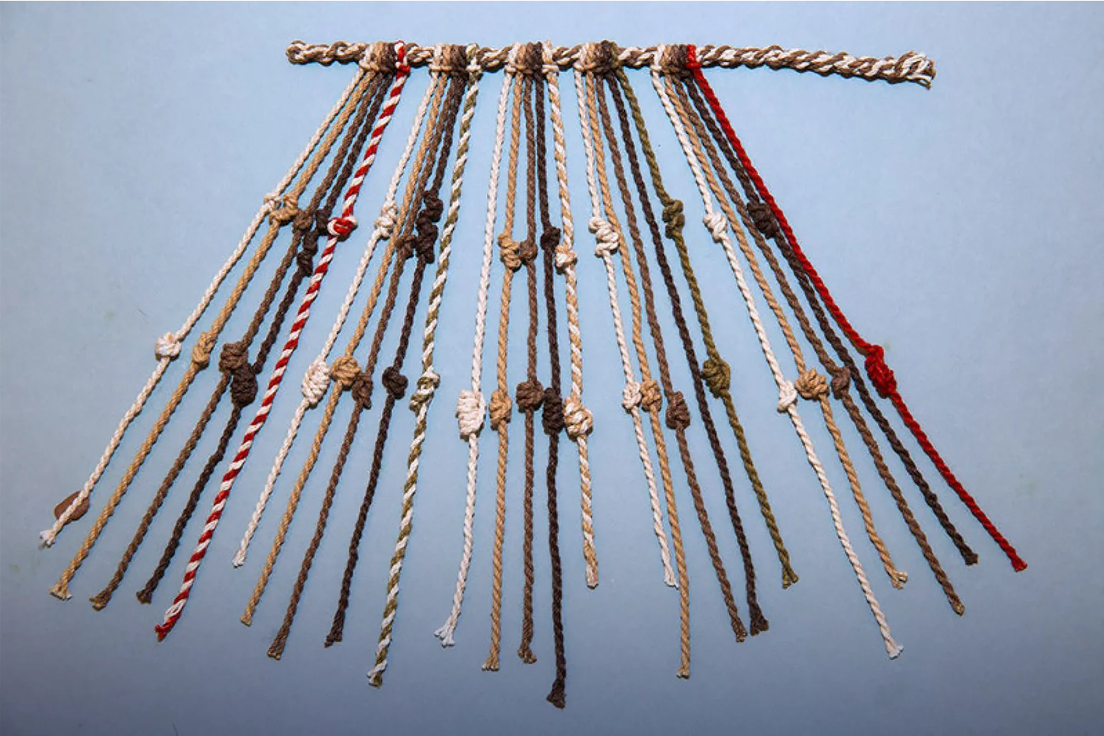
There are three distinct types, and they don't work the same way.
The first type is the easiest to decipher: a numerical accounting system. The knots represent ones, tens, hundreds, thousands. The colors and materials of the cords show what is being counted: corn, head of livestock, soldiers, sacks of seeds. Archaeologists and linguists have managed to interpret this type with fairly reliable accuracy.
The second type is much more mysterious. The cords are far more numerous, the knot positions are very close together, and the materials are more varied. Fewer than 50 examples of this type have survived, and no researcher has yet managed to fully decipher it. All we know is that it served as a link between the leader of a community and the imperial authorities. These Quipus could weigh several hundred kilos and required several people to carry them.
The third type is the most recent to give up its secrets. A researcher managed to decipher 40 % of its content by discovering that the name of the cord material or the name of the color in Quechua, combined with the attachment angle of the cord, formed a kind of alphabet. This is not an alphabet in the Western sense: it is a system that is both mathematical and semantic, and its interpretation was reserved for a caste of specialists called Quipucamayocs.
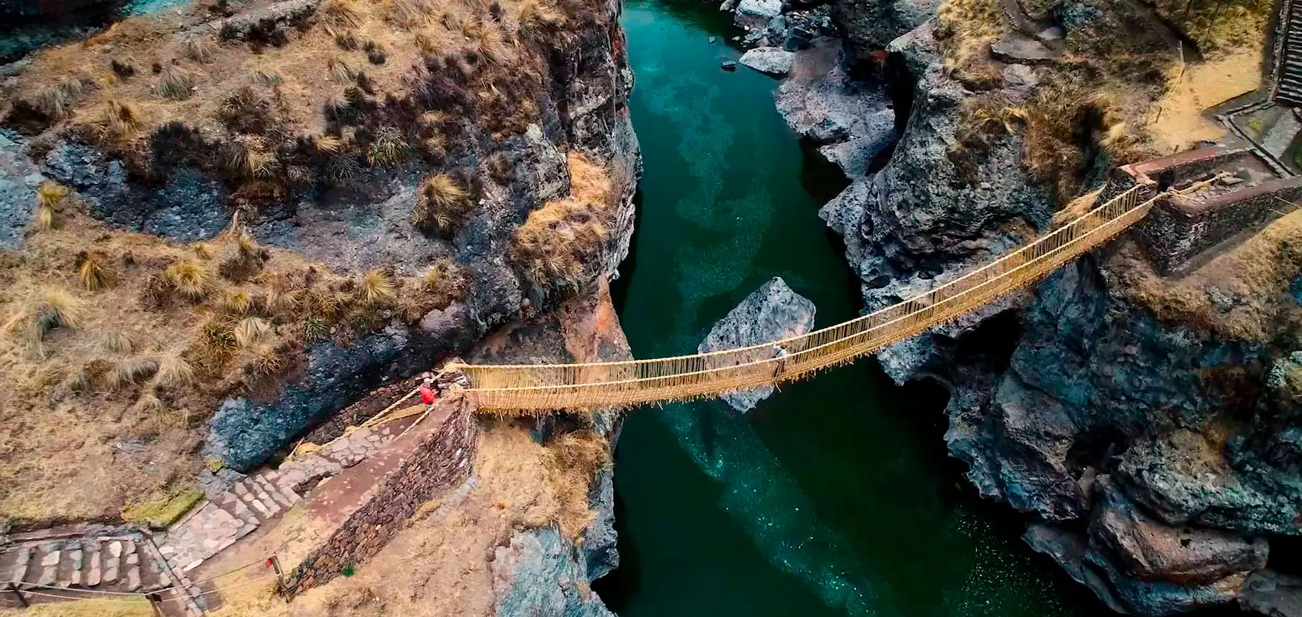
Suspension bridges: the predecessor to the zip line
The Inca road network had to cross dozens of deep canyons in the Andes. The solution developed by Inca engineers: the plant-fiber suspension bridge, an achievement that still challenges modern engineers today.
The longest organic suspension bridge ever found stretched nearly 3 kilometers, spanning the two walls of a canyon above a river, made of alpaca-leather ropes. Structures of this scale, built with natural materials and with no metal at all, could bear the weight of several people at once.
The last Inca suspension bridge still in use is called the Queshuachaca. It is 30 meters long and hangs above the Apurímac River, about 3 hours south of Cusco. This bridge is not a tourist reconstruction: it is completely rebuilt every year in June by the residents of the four local communities, who use exactly the same technique as in Inca times, with grasses from the Ichu family hand-braided. The rebuild takes three days, and the tradition is listed as UNESCO Intangible Cultural Heritage of Humanity.
In another vein, archaeologists found in the parks of the Cusco region an alpaca-leather rope dating back about 1,400 years before the Incas, at an altitude of 6,280 meters, during the ascent of a Bolivian peak. Which means that human beings were reaching altitudes of more than 6,000 meters with nothing but leather ropes and absolute faith, long before the Incas themselves even existed.
The annual ceremony to rebuild the Queshuachaca bridge takes place every June. If your trip to Peru coincides with that time, it's one of the most authentic experiences there is. Queshuachaca on Google Maps
To go further: The Apurímac Canyon, where Queshuachaca is located, is one of the deepest canyons in the Americas. It can be reached from Cusco in half a day by road.
Megalithic blocks: no mortar, no wheels, and no convincing explanation
It's probably the Inca engineering question that fascinates people most, and sparks the most theories: how did they move and assemble stone blocks weighing 180 to 220 tons without mortar, without metal wheels, and without any of the tools we consider essential?
At the Temple of the Sun (Qorikancha) in Cusco, the blocks of the megalithic base weigh between 100 and 220 tons. They fit together with millimeter precision, with no mortar at all. When an earthquake hits, the stones shift slightly against one another and then settle back into place: a seismic-resistant system that even our modern engineers still struggle to reproduce exactly.
At the Cachicata quarry, opposite the Sacsayhuamán site, granite wheels were found, which are one of the rare material proofs of the transport techniques used. The blocks were fitted with pegs that were inserted into grooves carved into these wheels, then gently lowered to the river without the stone breaking. Crossing the river. Stone working on site.
But transport alone doesn't explain the precision of the assembly. In 2007, then again in 2016, very advanced scientific analyses of the rock composition at certain Inca sites revealed something unexpected: by reading the geological properties of these stones, one can infer the Earth's diameter, its circumference, the distance from the Sun, and the Earth's speed of revolution. Data that Copernicus did not formulate until much later in the West, and that these stones seem to encode in one way or another.
For more on this: Sacsayhuamán, 3 kilometers from Cusco, is the Inca site where the megalithic blocks are the most impressive and the easiest to visit. Admission is included in the general Cusco tourist ticket (Boleto Turístico). Sacsayhuamán on Google Maps
The holes in the cliffs: how did they get up there?
As you travel through some Andean valleys, you come across a puzzling sight: openings carved into vertical rock walls, 200, 300, sometimes 400 meters above the ground. Some contain burials. Others seem to have been used for storage or as lookout points.
The question is simple: how did people get up there?
Only two explanations seem physically possible. Either these openings were reached from the top of the mountain, by rappelling down ropes, which the discovery of high-altitude alpaca leather ropes makes entirely plausible. Or access came from below, using some kind of scaffold or rope system built upward, of which no physical trace has survived.

What makes these openings especially intriguing is their deliberate placement. They are never random: they face precise astronomical alignments, overlook the meeting points of sacred rivers, or mark strategic passages in the local landscape.
The Chullpas of Sillustani, near Lake Titicaca, are among the most impressive funerary structures of pre-Inca civilization. They show a remarkable command of stone construction at high altitude and in extreme conditions. Sillustani on Google Maps


