Nazca Lines in Peru: history, geoglyphs, and mysteries
Discover the fascinating history of the Nazca Lines in Peru: ancient geoglyphs, construction methods, the life of Maria Reiche, and tips on how to visit this UNESCO site responsibly. Here is your complete guide, packed with details on budget, transport, and practical travel tips.
Nazca Lines in Peru: history, geoglyphs, and mysteries
The Nazca Lines are among the most fascinating archaeological mysteries in Peru. Etched more than 1,500 years ago into the Nazca Desert, these immense figures can only truly be appreciated from the sky. Designated as a UNESCO World Heritage site since 1994, they stretch over more than 450 km² between Nazca and Palpa. You can easily do a quick tour in a single day to see the most famous symbols before moving on with your journey! There is really no need to plan an extra day in Nazca, as there is not much else going on there.
The Nazca and Palpa Desert
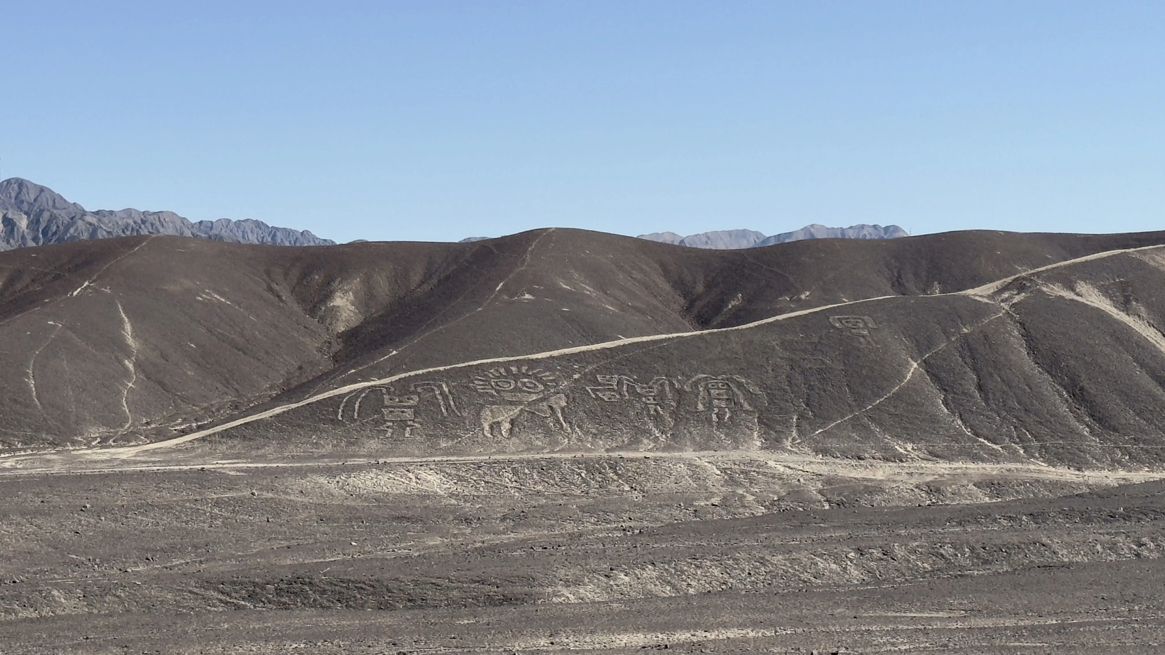
The Nazca Desert is located on a high, arid plateau nestled between the Pacific Ocean and the Andes. This pampa boasts unique conditions, with less than 20 minutes of rain per year. It's this extreme dryness that has preserved the geoglyphs for over 1 500 ans.
The Nazca Lines: giant drawings you can only truly appreciate from the sky
The Nazca Lines fall into three main categories. Biomorphic figures depict various creatures: the hummingbird (96 meters), the condor (134 meters), the spider (46 meters), the monkey (135 meters featuring its spiral tail), and the pelican (at 285 meters, that's the grandest figure of them all).
Geometric figures make up the largest group, and you'll spot triangles, trapezoids, spirals, and straight lines. Remarkably, some lines stretch for over 9 kilometers without a single bend. The trapezoids, reaching up to 700 meters, are often aligned toward underground water sources.
Phytomorphic figures represent plant life. The tree (or huarango), which you can easily spot from the viewing tower, measures 81.5 meters wide by 84 meters long. It honors the Prosopis, a sacred tree to the Nazca people.
What truly makes these designs mind-boggling is that you can only really appreciate them from the sky. It was actually Peruvian pilot Toribio Mejía Xesspe who first spotted them from an airplane back in 1927.
How were the lines built?
We learned that the Nazca people used a technique of subtraction: they cleared away the dark stones from the surface to reveal the lighter soil underneath. To get those perfect geometric lines, they used wooden pegs and ropes—very much like the techniques used by the ancient Egyptians.
They could actually complete a geoglyph in just a few weeks. But as for what they actually mean, we still only have guesses!

What the lines mean and how they work
Meaning and Function of the Lines: Water, Fertility, and Rituals
Maria Reiche first proposed the theory of a giant astronomical calendar. While some alignments do sync up with the solstices, statistical studies have shown that for most of the lines, these connections are nothing more than coincidence.
Today, the most widely accepted theory links the geoglyphs to rituals for water and fertility. The trapezoids point toward underground water sources (puquios), and the animal shapes represent creatures closely tied to water: the hummingbird (rain), the whale (the ocean), and the spider (a weaver of clouds).
Researchers believe these lines served as procession pathways. Communities would walk along these paths during ceremonies to pray for rain. The offerings found at the intersections, such as sea shells and broken pottery, back up this ceremonial use.
This explanation ties in beautifully with modern Andean communities where water rituals are still very much alive today. For instance, the village of Ollantaytambo in the Sacred Valley gives you a wonderful glimpse into how these pre-Inca traditions have stood the test of time.
The lookout figures
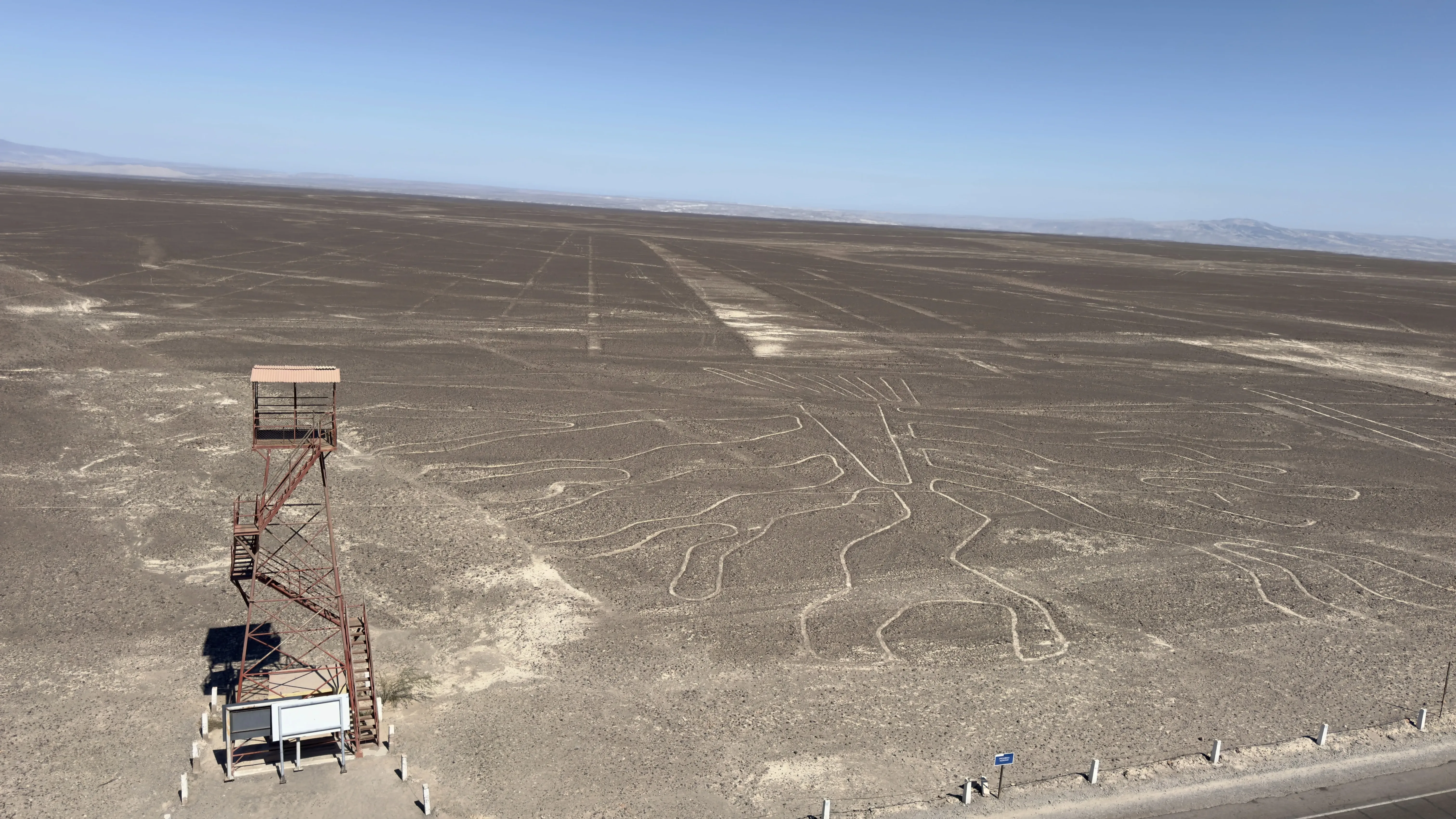
The Nazca mirador is a 13-meter tower right on the side of the Pan-American Highway. From this platform, we could clearly make out three of the geoglyphs: the crapaud (toad, 49x32.5 m), the arbre (tree, 81.5x84 m), and the lézard (lizard, 189 m). Depending on when you get there, the ticket booth to climb up may be open, and you'll just need to pay 50 centimes to go to the top.
Lookout point details
The Figures visible from the Observation Tower: Toad, Tree, and Lizard
The toad was a symbol of fertility and water abundance. Sadly, the construction of the Pan-American Highway in the 1930s cut right through a portion of this figure.
The Tree (or huarango) is one of the best-preserved figures here. It represents the Prosopis (algarrobo/mesquite), a vital tree in this desert ecosystem. Its deep roots reached down to the water table, symbolizing the connection between the underworld and the surface.
The lizard is the longest figure you can see from the observation tower. It too was cut in half by the Pan-American Highway. It was associated with regeneration (through shedding its skin) and the incredible ability to survive in these extreme conditions.
Maria Reiche: The Guardian of the Lines
We learned that Maria Reiche (1903-1998) was a German mathematician who dedicated 50 years of her life to studying and protecting the lines. After arriving in Peru in 1932, she discovered the spider figure in 1946 following a chat with a Peruvian colleague who told her about an unusual, intact line in the desert. This inspired her to publish "Secretos de la Pampa" in 1968. Thanks to her tireless fight to monument these lines, they were finally inscribed as a UNESCO World Heritage site on 17 décembre 1994.

Biography of Maria Reiche
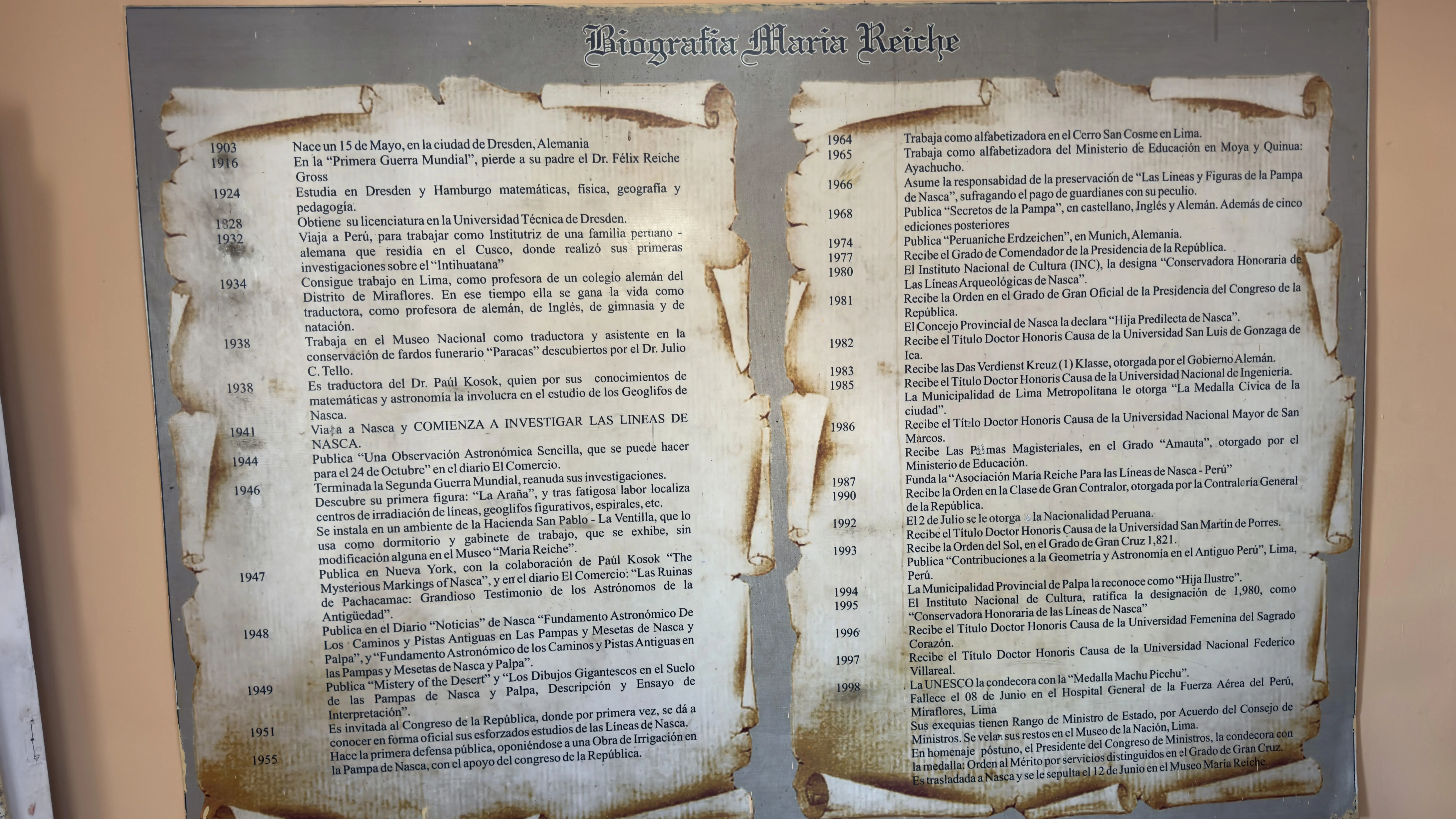
Born in Dresden, Maria Reiche studied mathematics in Hamburg. In 1941, she met Paul Kosok and found her true calling. She lived under Spartan conditions, even sleeping out in the desert to protect the geoglyphs. In 1998, she was awarded the Machu Picchu Medal and passed away in Lima at the age of 95. Today, her home welcomes visitors as a museum.
Fly over the Nazca Lines
The flight over the Nazca Lines lasts 30 to 60 minutes. Budget: 50 to 120 USD depending on the season. Flights run from 8:00 AM to 3:00 PM from Nazca airport. Be sure to choose a DGAC-certified airline. A quick tip: take some motion sickness medication 30 minutes before boarding. Free alternative: you can check them out from the viewing tower on the Pan-American Highway.

Timeline of the geoglyphs
Timeline: From Paracas Culture to UNESCO
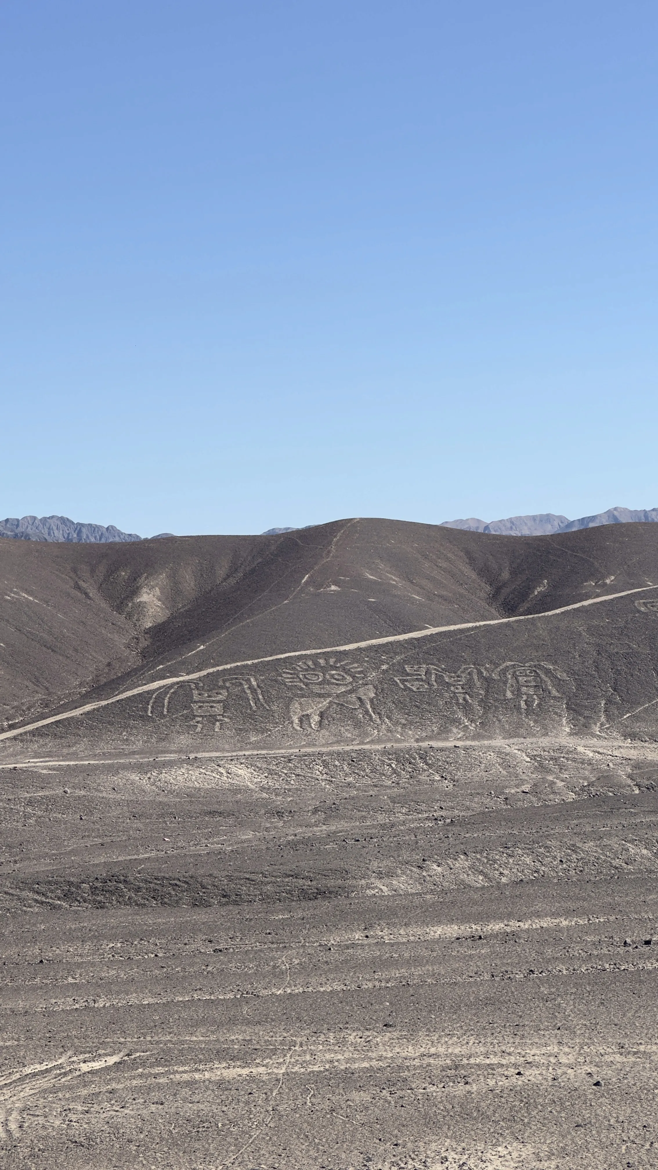
800 to 200 BC (Paracas): The very first geoglyphs appear in the Palpa region, featuring human-like figures carved into the hillsides.
1 to 650 AD (Nasca Period): The golden age of the geoglyphs. The Nasca civilization creates most of the famous figures we see today, masters the "puquios" (ingenious underground aqueducts), and develops stunning, colorful pottery.
650 to 1000 AD: The rise of Wari influence marks the end of this creative era. The lines fade from memory, lay undisturbed, and are forgotten for nearly a thousand years.
1927: Toribio Mejía Xesspe spots the figures from a plane. 1941: Kosok and Maria Reiche begin their life's work of systematic study. December 17, 1994: The site is officially inscribed by UNESCO.
2019: A Japanese team discovers 143 new geoglyphs using artificial intelligence. Planning your next adventure? Don't miss our guide to the 7 wonders of the world.
Responsible travel in Nazca
Responsible travel in Nazca: never stray from the marked trails. Your best bet is to take the bus from Lima (an 8-hour ride with Cruz del Sur or Oltursa). Support the local community by staying at family-run hospedajes and eating at traditional picanterías. Make sure to pack out all your trash. Don't forget to check our travel checklist.
A few tips for traveling responsibly
Protecting a fragile heritage
The journey to Nazca fits perfectly into an itinerary between Peru and Chili. Combine it with San Pedro de Atacama and the Uyuni salt flat for a complete trip spanning coastal deserts and the altiplano.
Volunteering opportunities are available in the region. Our guide on volunteering in South America through Workaway shows you exactly how to find placements. You can also read about our experience volunteering at an animal rescue center in Peru.